Thursday, September 16, 2010

Highway 95

Somewhere in Utah

After narrowly escaping a fierce dust storm, Kate and I went on Highway 95 to reach the day's final destination: Natural Bridges National Park.This leg of the trip should've taken about two hours, but I'm pretty sure Kate and I added on at least an hour from all the stops we took to take pictures. The first gasp was at this overlook where we spied the gorgeous turquoise waters of the Colorado River.
Next we hopped out at Hite Overlook, which has a breathtaking view of Lake Powell. We got to chatting with a local Utah man at the overlook, who told us that in past years the water level has been much lower. He seemed pleased to hear that we found the area so beautiful, saying that those who live around there tend to take it for granted. He was also quite excited to find out that I'm from the Philippines. He had just sent off his daughter to Bacolod on mission for the Church of Latter Day Saints. I told him their church in Manila is stunning, and that he should come visit her and try the delicious food in Bacolod.
We only stayed in the car long enough to navigate the steep descent down to Lake Powell. The sight of the red cliffs towering over the glassy blue waters was just too beautiful to ignore.
Let's stop for a second to appreciate this awesome Highway 95 picture that Kate risked life and limb for ...
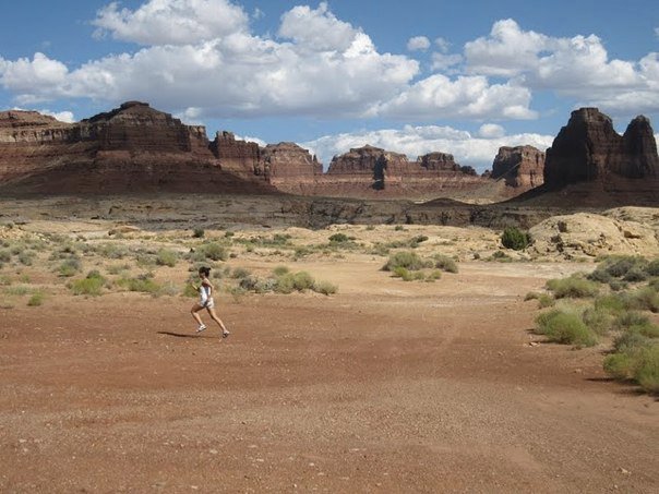
Not more than 5 minutes from there, we stopped to gawk at tall buttes and take running pictures to mix things up a bit.
Finally, we make a tiny bit of headway and get to Hite Crossing Bridge, which traverses the Colorado River.
From there we contained our instinct to snap away so that we could get to Natural Bridges in time to secure a campsite and put up our tent before dark.

When we planned this road trip, we thought that this leg of the trip would be the most tedious since it involved over five hours of driving and going through two national parks. As it turns out, the journey itself was even more memorable than our destinations. There's just something so special about chancing upon wonderful sights when you least expect them. For road trip enthusiasts out there, I highly  recommend adding this Highway to your to-do list!  

Wednesday, September 15, 2010

Highway 24

Somewhere in Utah

From Highway 12, we turned on to Highway 24 and found ourselves on Mars. Suddenly, we were driving along a vast, desolate expanse of red earth surrounded by towering cannons and boulders balanced precariously on the canyon’s edges.

"Caution: Falling Rock. That’s nice," Kate quipped with her dry English humor as she  read the road signs aloud. We pulled over on the deserted road to gawk and take pictures of the alien-like scenery. We were in Capitol Reef National Park.
Capitol Reef National Park contains a spectacular section of the Waterpocket Fold, a nearly 100-mile fold in the earth’s crust. I can’t explain the phenomenon in my own words so I’d best quote from the National Park Service website:
The Waterpocket Fold formed between 50 and 70 million years ago when a major mountain building event in western North America, the Laramide Orogeny, reactivated an ancient buried fault. When the fault moved, the overlying rock layers were draped above the fault and formed a monocline.
We would have wanted to do the scenic drive through the park, go on a hike to see the Waterpocket Fold, and pick apples and pears from the Fruita orchards. But  time wasn’t on our side, for one, and then the rain started pouring. Since flashfloods are a serious threat in this area, we decided to cut our losses and continue on our trip. We were at least able to snap photos of a few sights along Highway 24, like Chimney Rock ...
... Castle Rock ...
... and some ancient petroglyphs created by the Fremont Indians who occupied the area nearly 1,000 years ago.
The drive out of Capitol Reef was very pretty, in any case. At some point, it seemed we had gone from Mars to the moon.
Before making the turn to Highway 95, we stopped at a dusty roadside store to buy bread and have a quick lunch. While we were digging into our leftover curried chickpeas and couscous, a biker pulled over and shared our table to upload the photos he’d taken on a mounted camera to his laptop. He was an English fellow who’s been living in Los Angeles for the last 20 years, and was doing a solo road trip following a similar path to ours but perhaps ending up somewhere in Montana eventually. He hadn’t decided yet. I wonder what it feels like to travel that freely ...

Just as we were wrapping up our lunch, a dust storm started to brew around us so we hurriedly said goodbye and hopped on to our respective vehicles.
Together, we turned into Highway 95 where, like the fitting ending to a movie,  we watched our friend drive off into the horizon.

Quick Update #2

Just dropping in to let you all know that I'm alive, well and smiling ear-to-ear after four fantastic days at Ribeira Surf Camp. I absolutely fell in love with surfing and the warm culture of the surfing community, and made some really cool new friends along the way. I've been keeping a digital diary on my BlackBerry for most of the trip, so those posts should be up soon once I'm back on American soil. For now, I have a few days doing the tourist thing in Lisboa. Will check in with you all very soon!

Beijos!

Saturday, September 11, 2010

Quick Update #1

Hey everyone! Just a quick little update to let you know I haven't been lost in espuma. I am alive and well, just didn't have Internet access in Ibiza. Managed to get online here in Lisbon but I am hopping on a bus to Ericeira soon and I don't know if there'll be access at the surf camp. Crossing fingers! So a quick little update:
  • Ibiza was LEGENDARY! Espuma, F*** Me I'm Famous with David & Cathi Guetta, dancing my ass off, sailing to formentera, sunbathing topless, boozy nights, and still unexplained minor drinking injuries! Lengthy posts to come once I am back on American soil.
  • I am now in Lisbon and shortly heading to Ericeira for five days at Ribeira Surf Camp for four and a half days of surfing lessons! I am honestly still completely exhausted from Ibiza and will have to dig deep for some energy to surf. I hope I'll perk up when I get there!
Talk to you all in a few!


Hugs,

Friday, September 03, 2010

Off to Ibiza!

I had ambitious hopes of being able to write all my road trip tales down before leaving for Europe so that I could leave you all with reading material while I go off and play ... but alas, life (and my real job) tends to get in the way of blogging so it might be a couple of weeks of silence here. Unless Hurricane Earl decides to put a damper on our plans, I am off to Ibiza tonight for a week of sun and debauchery ...
After Ibiza, I move on to Portugal, where I'll be holing up at a surf camp for five days and then exploring Lisbon for a few more. I will be off the Internet during the week in Ibiza but may be able to put in some posts once in Portugal.

See you in few! I'll try my darndest to come back with more great stories to tell ;-)


Image via wippermann.net

Highway 12

It's been said that Utah's Highway 12 is a destination in itself, and after being stunned by our drive through it, I would have to agree. We started out on Highway 12 on Day 3 of our road trip as we made our way to Bryce. The scenic byway rolls through Red Canyon, which just begs you to jump out and take pictures of hoodoos and arches.
We stopped at Bryce for the rest of the day, and early the next day went right back on Highway 12 for the 2-hour 40-minute drive to Capitol Reef. 
View Larger Map

We started out a tad glum, sad from having to skip the hike into Wall Street and weary at the thought of driving to Capitol Reef and then Natural Bridges all in one day. But all that quickly gave way to sheer amazement when we realized what a treat we were in for driving Highway 12. You know you're somewhere special when the scenery goes from this ...
... to this in just a matter of minutes.
From Bryce Canyon, Highway 12 crosses into parts of the Grand Staircase-Escalante National Monument, which accounts for the continuously changing colors of the cliffs and canyons surrounding the road. I distinctly recall traversing the road above and finding ourselves surrounded by cream colored cliffs and fields rolling with pistachio and seafoam colored plants. The scenery on this road is nothing short of breathtaking.
We stopped at every overlook possible, but nothing prepared us for the one that hangs over what's known as "Hog's Back." The scenery is breathtaking, as is the path traversed by the road over a narrow canyon surrounded by 2000-foot drops. Here's Kate soaking it all in before we tackled Hog's Back. I'm not sure if she's appreciating the gorgeous vista or contemplating pushing me off for making her do all the driving for this trip. I'd like to believe it's the former.
The only problem with Highway 12 is that cellphone reception is spotty to nonexistent, and there aren't many other cars traveling on it. The isolation is great if you're car's running well, but I shudder to think what would've happened if we'd had car trouble. This is a road lined with cows crossing signs and no pedestrian lanes. Sure enough it was easier to spot cows than people on the road.
Thankfully we were never in need of rescuing and just had a truly wonderful time getting surprised at every turn. This road was an absolute gem on our trip. If you ever feel the need to get away and hit the road, I highly recommend adding a romp down Highway 12 to your itinerary. 

Thursday, September 02, 2010

Road Trip Stop #2: Bryce Canyon

Still high from the gorgeous drive and refreshed after finally getting to some pay showers, Kate and I ventured out to see Bryce Canyon's famed hoodoos. I didn't even know such things existed before we started planning this trip, but I've been enthralled with them since discovering them. Explaining the origin of hoodoos requires a lengthy geology lesson so let's just say that these are rock formations that have been sculpted by ice and water (If you're really interested though, page 4 of the Bryce Canyon summer newspaper discusses hoodoo formation at length). Hoodoos can be found in other parts of the world, too, but nowhere are they as abundant as in Bryce.

The view that impressed us most was at Bryce Point. When you step up to the edge of the rim, you're rewarded by a seemingly endless parade of hoodoos in every shape, size and hue. It is absolutely mind-blowing. Click on the images below to enlarge. Believe me, you want to.  
Bryce Point is a great vantage point to see the beautiful grotto formations within Bryce Amphitheater. I would be impressed if an architect designed forms like these. To think that all of this was sculpted by Mother Nature truly blows my mind. 
Bryce Point is also a great place to see nature's finest paintings. How beautiful is the dégradé on the amphitheater's wall?

We also visited Sunrise Point, where I was smitten with the fin-like, jagged patterns. We didn't wake up early enough to see the sun rise over Bryce Amphitheater, but I'm sure these colors look even more sublime in the early morning light.
Sunset Point gave us a great view of the portion of the amphitheater referred to as Wall Street for its towering columns and narrow passageways below. I am still heartbroken that we weren't able to hike into Wall Street and experience being surrounded by the towering hoodoos. We so badly wanted to be down there when we spied the people below but the sun was about to set and we were clad in flipflops so it wouldn't have been safe. Lesson learned: Always be ready for a hike! We woke up early the next day hoping to venture down to Wall Street but alas, it started to rain—and no one wants to be on the floor of the amphitheater when water's pouring from the heavens. I would come back to Bryce in a heartbeat for another shot at this hike.
Bryce was definitely one of the highlights of our trip. The intricate patterns and formations of the hoodoos and the sheer abundance of them was more impressive and jaw-dropping to me than the vastness of the Grand Canyon. Seeing this spectacular park is just one of the many fortunate side effects of my little 30 Before 30 Project. If it isn't already on your bucket list, it should be!

Wednesday, September 01, 2010

Highway 14

We didn't expect the driving part of our road trip to be just as remarkable as the sights we were driving to but it turned out that our route had some wonderful surprises for us. The drive from Zion National Park to Bryce Canyon was one of many beautiful drives that we had during this trip, particularly because of Highway 14, that 40-mile stretch connecting I-15 and US-89.

Also known as the Markagunt High Plateau Scenic Byway, this road courses past Cedar Breaks National Monument and is enveloped by Dixie National Forest. On the road, the thick cover of pine trees occasionally broke and allowed us peeks at Cedar Breaks' vibrant red, orange and purple-hued canyons.
A lookout point had a sublime view of Zion's highest cliffs and Kolob terraces.
And then, a sudden splash of turquoise from the Navajo River.
I was so smitten by this drive that when a guidebook suggested that the drive we had scheduled for the next day was a "destination on its own", my initial reaction was, "I can't imagine how it could be better than today's."

Well it was. Check back for the post on Highway 12!

Related Posts Plugin for WordPress, Blogger...